Introduction to Mount Rinjani
Nestled on the stunning island of Lombok in Indonesia, Mount Rinjani stands as an iconic symbol of natural grandeur and geological significance. As the second-highest volcano in Indonesia, Rinjani has attracted countless explorers, nature enthusiasts, and adventure seekers from around the globe. Its mesmerizing landscapes, diverse ecosystems, and cultural heritage make it a must-visit destination for those eager to witness one of Southeast Asia’s most spectacular volcanic formations.
This comprehensive guide aims to delve into every aspect of Mount Rinjani, from its geographical and geological features to practical tips for trekking, conservation efforts, and tips for planning an unforgettable journey. Whether you’re a seasoned trekker or a curious traveler, understanding the majesty and complexity of Rinjani enriches your experience, allowing greater appreciation of its role within Indonesia’s rich natural tapestry.
Geographical Location and Significance of Rinjani
Mount Rinjani is situated in the northern part of Lombok, within the boundaries of Gunung Rinjani National Park, a protected area recognized for its outstanding biodiversity and ecological importance. The mountain forms a prominent feature of the island’s landscape, rising dramatically from the surrounding plains and forests. Its strategic location at the heart of the island makes it a vital geological and cultural landmark.
Rinjani’s prominence is not merely physical but also symbolic. As an active volcano that has shaped the local climate, agriculture, and cultural practices for centuries, it has been central to the identity of the Sasak and Lombok communities. Its position within the Wallacea biogeographical zone provides a unique transition point between Asian and Australasian flora and fauna, making it a hotspot for biodiversity.
The mountain also holds historical importance, as its eruptions and geological activity have influenced regional climate patterns and historical events. The 1257 eruption of its predecessor, Gunung Samalas, is believed to have triggered a global climatic event, underscoring Rinjani’s profound influence beyond local boundaries.
Physical Characteristics and Height
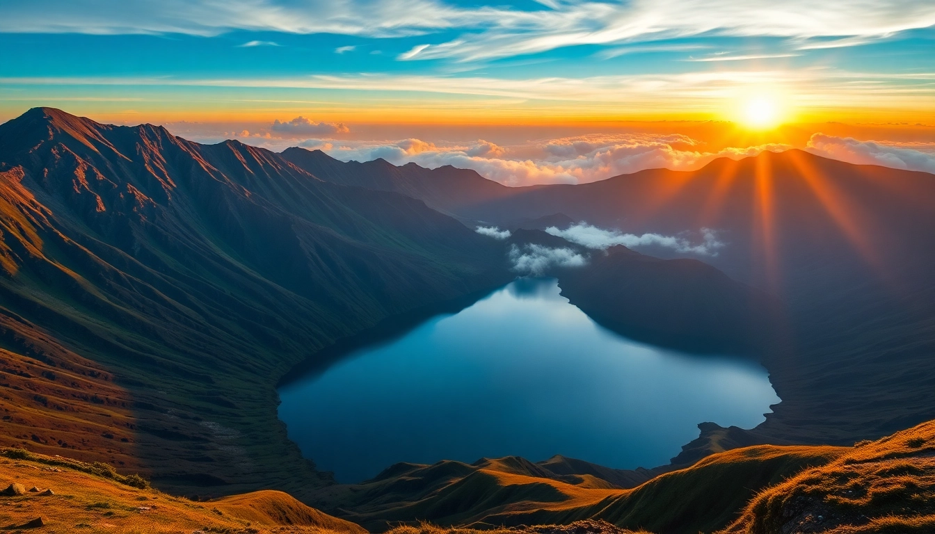
Standing at an elevation of approximately 3,726 meters (12,225 feet) above sea level, Mount Rinjani is a towering volcanic massif that commands the Lombok skyline. Its twin peaks, with the active crater roughly 2,641 meters (8,668 feet) wide, create a dramatic silhouette visible from many parts of the island.
The volcano consists of a complex caldera system, measuring about 8 by 10 kilometers, which houses the breathtaking Segara Anak crater lake. This crater lake is not just a visual marvel but also the source of the mountain’s geothermal features and hot springs, adding to its ecological and spiritual significance.
The geological architecture of Rinjani results from multiple eruptions over thousands of years. Its layered lava and ash deposits have built up a terrain characterized by rugged slopes, lava fields, and lush vegetation zones, transitioning from tropical forests at lower elevations to alpine and montane ecosystems higher up.
Historical Eruptions and Geological Insights
Mount Rinjani is an active volcano, with its most significant eruption historically recorded in 1257, originating from its ancestral volcano, Gunung Samalas. This eruption is one of the largest volcanic events in Indonesia’s history, spewing an ash plinian column that reached the stratosphere and caused global climatic disturbances, including a temporary drop in temperatures worldwide.
Since then, Rinjani has experienced periodic activity, with minor eruptions and geothermal phenomena continuing to shape its profile. The volcano’s ongoing activity is monitored closely by geological agencies, and it is classified as a higher-risk volcano due to its proximity to populated areas and tourist routes.
From a geological perspective, Rinjani exemplifies the complex tectonic interactions at the convergence zone of the Indo-Australian and Eurasian plates. Its composition primarily includes andesitic and basaltic magma, indicative of magmatic differentiation processes typical of subduction zones. Studying Rinjani provides key insights into volcanic behavior, risk assessment, and the broader tectonic dynamics of Southeast Asia.
Top Attractions and Natural Beauty of Mount Rinjani
Crater Lake Segara Anak
At the heart of Mount Rinjani lies the stunning Segara Anak crater lake, a pristine body of water filled by volcanic activity. Its emerald-green hue, often contrasting with the ash-gray volcanic terrain, offers one of the most spectacular sights on Lombok. The lake’s name translates to “Child of the Sea,” reflecting its deep blue waters and mystical aura.
Visitors often trek to its shores for camping, Picnicking, or simply soaking in the breathtaking panorama with views of the surrounding caldera walls. Nearby hot springs provide relaxing retreats after challenging hikes, adding to the allure of this natural wonder.
Rinjani Waterfalls and Hot Springs
The Rinjani area is dotted with numerous waterfalls and geothermal hot springs, owed to its volcanic activity. Famous waterfalls such as Sendang Gila and Tiu Kelep are lush, cascading over rocky cliffs, accessible via scenic hiking trails. These falls serve as refreshing stops and are popular among trekkers.
The hot springs around the mountain, like the Aik Nyet Hot Spring, are renowned for their therapeutic waters that are rich in minerals. These geothermal features not only attract tourists but also contribute to the local community’s socio-economic development.
Biodiversity and Unique Flora & Fauna
The diverse ecosystems of Mount Rinjani’s national park harbor an impressive variety of flora and fauna. The lower slopes are lush with tropical rainforests, home to species such as the Lombok jackal, various primates, and endemic birds. As altitude increases, the flora shifts to montane forests and alpine grasslands, hosting unique orchids, Edelweiss-like flowers, and mosses.
Conservation efforts aim to protect these ecosystems, which are under threat from deforestation, illegal logging, and habitat encroachment. Biodiversity monitoring programs continue to document the rich biological tapestry of the Rinjani region.
Guided Trekking and Best Practices
Popular Routes and Duration
Trekkers have several routes to choose from when ascending Mount Rinjani. The most popular is the Sembalun route, known for its scenic views and manageable steepness, typically taking 3-4 days. Another common route is from Senaru, offering lush forests and cultural experiences, usually spanning 3-4 days as well.
The trek generally covers 27-32 kilometers, depending on the path taken. It involves a combination of daytime hiking, camping overnight within the park, and summiting at dawn to witness spectacular sunrise vistas.
Equipment, Safety Tips, and Preparation
Proper equipment is crucial for ensuring safety and comfort during Rinjani hikes. Essential gear includes sturdy hiking boots, layered clothing suitable for fluctuating temperatures, a warm sleeping bag, rain gear, and a headlamp. High-altitude acclimatization and physical conditioning are vital, especially considering the mountain’s challenging terrain.
It’s recommended to hire local guides authorized by the national park, as they are familiar with the routes, weather patterns, and emergency procedures. Permits are mandatory for trekking, obtained through official channels or local tour operators.
Local Guides and Permits
Guided treks are strongly advised to enhance safety, ensure environmentally responsible travel, and support local communities. Guides provide valuable insights into the mountain’s geology, flora, fauna, and cultural stories. Permits, typically arranged by guides or trekking companies, help regulate visitor numbers and preserve the park’s ecosystem.
Tourism and Conservation Efforts
National Park Regulations and Preservation
Mount Rinjani is protected within Gunung Rinjani National Park, which enforces strict regulations to safeguard its natural and cultural resources. Visitor access is controlled through permits, and certain areas are restricted to minimize ecological disturbance. Campfires, littering, and illegal carving are prohibited.
Park authorities actively engage in reforestation projects, erosion control, and environmental monitoring. Education programs help visitors understand the importance of preserving Rinjani’s fragile ecosystems for future generations.
Community Involvement and Eco-Tourism
Local communities play a pivotal role in Rinjani’s sustainable tourism initiatives. Many villagers serve as guides, porters, and accommodation providers, benefiting directly from tourism revenue. Initiatives encouraging eco-tourism emphasize responsible practices, cultural preservation, and community empowerment.
Programs such as waste management and zero-impact trekking are promoted to reduce environmental footprints. These collaborative efforts foster a balance between tourism growth and ecological conservation.
Visitor Information and Responsible Travel
Responsible travelers respect local customs, adhere to park regulations, and minimize waste. Planning visits during the dry season (April to October) ensures better weather conditions, while avoiding peak months helps reduce overcrowding. Supporting local businesses and choosing eco-friendly tour operators further enhances sustainable tourism.
Planning Your Visit to Mount Rinjani
Best Time to Trek and Seasonal Tips
The optimal period for trekking Mount Rinjani is during the dry season, from April through October, when weather conditions are more predictable, and trails are less muddy. The peak months, July and August, see increased visitor numbers, so early bookings and flexible planning are advisable.
During the rainy season (November to March), trails can become slippery, and weather conditions unpredictable, making trekking more dangerous. However, the landscape is lush and vibrant at this time, appealing to trekkers willing to face the challenges.
Accommodations and Local Services
Lodging options near the park range from basic guesthouses in Sembalun and Senaru villages to eco-lodges and campsites within the park. Many tour operators provide package deals, including permits, guides, and equipment rentals.
Local services such as trekking gear shops, food stalls, and transportation are readily available. Planning your logistics and booking in advance ensures a smooth and enjoyable experience.
Sample Itinerary for a Memorable Trek
A typical 3-day trek involves:
- Day 1: Arrival at base village, briefing, and acclimatization walk. Night camping near post-1.
- Day 2: Ascend to the crater rim, view of Mount Rinjani’s summit, and descent to the crater rim to camp.
- Day 3: Early morning summit attempt, sunrise view, then descent back to the base for departure or continuation to nearby attractions.
This schedule offers a balance of adventure, rest, and sightseeing, accommodating different trekking paces.